


Hurricane Hilary blossomed overnight into a powerful Category 4 hurricane in the eastern Pacific and beginning this weekend will aim a tropical firehose at some of the driest places in the U.S., creating the potential for life-threatening flash flooding from Southern California to western Arizona, Nevada, and southwestern Utah.
Meanwhile across the crowded tropical Atlantic, up to four systems show potential for development, with possible impacts by early next week to southern Texas and the eastern Caribbean. For now, no significant threats are anticipated to South Florida.
The area with the highest chance of development in the Atlantic – the easternmost disturbance designated Invest 98L – will be staying over open water for the foreseeable future and poses no threat to land.
To the west of 98L lie two other areas we’ll be watching – Invest 99L and a nearby tropical wave. Although development odds are modest for Invest 99L, its development window is narrow, with increasing wind shear halting any organization by late weekend. 99L is not a concern for land areas.
The tropical wave west of 99L that’ll be approaching the eastern Caribbean islands late tomorrow – not yet designated an Invest – will need to be watched into early next week.
At a minimum, it will bring the potential for squally weather, heavy rainfall, and flash flooding to parts of the Lesser Antilles on Sunday into Monday. The system will continue westward into the central Caribbean where conditions appear conducive for slow organization next week. For now, it looks to make a turn northward into a break in westward-guiding high pressure by mid-week before getting too far west. It’s still early in the forecast so we’ll want to follow the trends.
The most immediate tropical impact on the Atlantic side will come early next week from a disturbance that’ll be moving across the Florida Straits tomorrow.
Although we’ll see widespread showers and locally heavy rainfall from the system on Saturday in South Florida, it isn’t expected to develop before reaching the Gulf.
Once over the Gulf of Mexico on Sunday and Monday, there will be an opportunity for a short-lived storm to form as it heads toward the Texas coastline. Assuming limited time and organization over water, the rains could be a good-news story for parts of drought-stricken south Texas. Of course, this assumes not too much rain at once, so interests in south Texas should continue to monitor the forecasts.
The biggest weather story next week will come from the waning circulation of Hurricane Hilary in the eastern Pacific. Although the now Category 4 hurricane is expected to rapidly weaken on approach to Southern California late Sunday, the intense surge of tropical air ahead of it colliding with rugged terrain will produce a dangerous setup for widespread flash flooding, especially on east-facing slopes into the adjacent deserts.
Flood watches have been posted over a wide reach of the western U.S., including parts of California, Arizona, Nevada, and Utah.
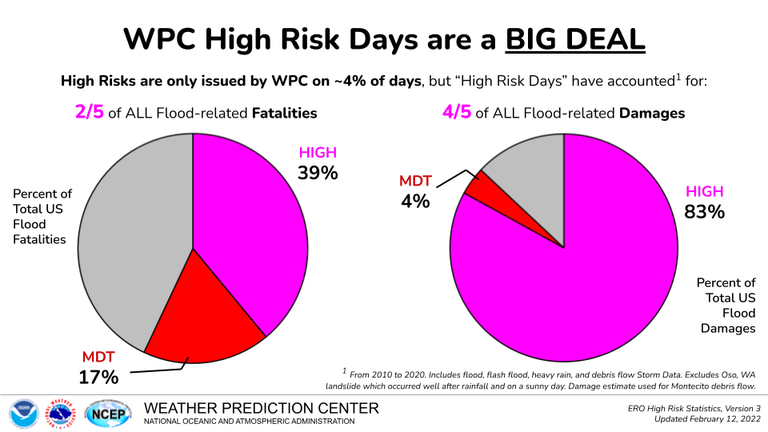
The National Weather Service this morning issued a first-ever high risk for excessive rainfall east of the mountains and low deserts of Southern California. These uncommon high-risk rainfall outlooks only happen on 4% of days but account for over 80% of total U.S. flood damages and nearly 40% of all flood-related deaths.
While Hilary’s circulation will be quickly shedding its tropical characteristics as it arrives over Southern California, it’s still expected to produce tropical storm winds that will be amplified through the mountains and passes.
"crowded" - Google News
August 18, 2023 at 09:31PM
https://ift.tt/FMqksVG
Crowded Atlantic as powerful Hurricane Hilary opens a tropical tap over Southern California - WPLG Local 10
"crowded" - Google News
https://ift.tt/o17fG3M
https://ift.tt/ACJwRck
Bagikan Berita Ini


0 Response to "Crowded Atlantic as powerful Hurricane Hilary opens a tropical tap over Southern California - WPLG Local 10"
Post a Comment